HAMILTON ISLAND RACE WEEK: RACING PREPARATIONS
Be Ready For A Variety Of Conditions
Hamilton Island Race Week provides plenty of conditions that provide challenging sailing for all types of boats. The wind swirls around the islands and the water funnels down passages and taking these local effects into account is both an essential tactical tool and great fun. While the wind is difficult to predict even a short distance ahead, the movement of water, being directly related to the positioning of the sun and the moon around the earth, can be predicted with great accuracy well into the future. This provides a good opportunity to familiarize oneself with the anticipated flow patterns around the islands during each race and can be done well in advance of even arriving at Hamilton Island.
I find that it helps to visualize the movement of the water around the islands and to aid this visualization it is useful to review a few basic principles of how water responds in certain situations.
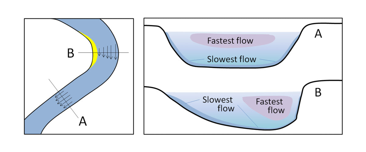
- Because water is relatively heavy it has a high inertia. That is, once it has started moving it wants to keep moving and keep moving in the same direction. This means that if there is a bend in a channel then the current will run strongest on the outside of the bend.
- When an obstruction is put in its path the volume of water flow cannot change, so the water must accelerate to compensate for the reduced flow path denied it by the obstruction.
- Typically, tidal flow is slower in shallow water, than deeper water.
- Downstream effects are much more pronounced than the upstream effects. An extreme example of this is seen at a waterfall. Upstream of the falls the water can be calmly meandering along in an almost unnoticeable flow, but upon the water reaching the edge it cascades down the face in a catastrophic flow that continues a great distance downstream.

Now let’s look at some aspects of the tides in the Whitsundays. The tidal currents in the Whitsundays generally flow parallel to the coast of Queensland. So, it floods to the SE and ebbs to the NW.
The tidal range increases the further south one travels. That is, Thomas Island in the south has bigger tides than Hayman Island in the north. This translates into stronger tidal flows in the south when compared to the north. The tide turns slightly earlier in the north than in the south, so have a good look at the tide tables that are applicable to your race area.
The BOM has 2021 tidal predictions available for download for Hayman Island, Shute Harbour, Cid Harbour, and Thomas Island.
The tidal streams will generally turn between 10 and 30 minutes before the time of high or low water. This may vary with atmospheric pressure, and duration and intensity of the prevailing winds and can be difficult to pick exactly but is nonetheless critical to watch for. Times of tidal change is particularly important in deciding when to cross the Whitsunday Passage. Look up and understand the “Rule of Twelfths” which gives a simple prediction for the flows during a typical 12-hour tidal cycle. If the tide is in the first part of the cycle it may be better to cross early, whereas if the tide is in the latter part of the cycle it may pay to work up the side you are on and cross later when the stream has decreased.
Look at the tidal range between high and low tides. The bigger the difference the stronger the flow and the more significance the currents will have. When you get to Hamilton Island a good place to put to practice your visualizations is right in front of the marina in the Dent Passage where the Dent start/finish line is located. Sail around exploring the currents (being careful not to intrude on the runway exclusion zone) and practice a few of the following situations likely to occur during the week.

Starting in a flood, the current will be flowing south down the passage. Because the area upstream is fairly open the strongest flow will be in the center and can run at 2 – 3kts, so it is important to stay close to the line or risk being late for the start. Titan Island projects into the flow on the west side and there is a small submerged spit just north of the Yacht Club on the east side. Look for the small back eddies on the south side of both these intrusions.
Starting in an ebbing tide, the flow is to the north. Cowie Island at the center of Dent Island and the airport runway extension into the passage both influence the currents markedly. If you look at the depth contours on the chart you will see how the western shore to the south of Cowrie Island has been scoured out by fast-flowing water. This fast flow is then constricted at Cowrie Island and is directed to the NE. This constriction and acceleration produce quite a narrow river of water aimed at Hamilton Island which in earlier days would have run along the eastern shore of the Island. However, with the construction of the runway extension, this river of flow is now deflected NW. This makes for a strong concentration of flow near the middle of the passage which decreases slowly toward the western side but decreases quickly into a back eddy in the current lee of the runway at the marina entrance. Great care is needed not to be swept across the start line early with the ebb. When finishing from the south this rapid change of current direction from NE at Cowrie Island to NW at the runway coupled with a geographical wind header coming down the runway usually provides great entertainment for onlookers as boats struggle to make the finish limit mark while trying to hold their spinnakers.
Finishing from the north with a flood tide is relatively straight forward but finishing from the north with an ebb tide is a little trickier as the river of flow off the runway extension fans out evenly across the passage as it moves north and there is no easy escape route. Throughout your practice look for clues on the water surface that might show what is happening with the current. Wind against current produces choppy water while wind with current produces calm-looking water. Look for current indications on the mooring buoys by the Dent shore. Watch the movement of the land across your bow as you head across the passage. Every available resource should be used to spot where the current might be accelerating in your favor or where there might be a back eddy to be used against the general flow.

Be aware that current patterns will change depending on the state of the tide. Flow around a rock that is awash at low tide will be very different from when there is 4m of water over it at the top of the tide. This is what makes reading the currents such an interesting exercise. Potential current gains from close inshore back eddies also need to be balanced against potential losses from island wind shadows. A prime example is when beating down the western shore of Dent Island in an ebb tide. With the current flowing NW, there is good relief to be had along the shore by tucking into some of the small bays, particularly north of the lighthouse, but there are also some very light patches of wind and big shifts because this area is in the lee of the island.
Despite the likely benefits of getting very close to the shore to avoid the tidal flow, don’t get too greedy. There are numerous rocks and bommies which are not necessarily marked on the chart which you might pass over one day, but not be so lucky the following day at a slightly lower tide. When it comes to regatta time, before every race, as part of your race briefing, it is a good idea to show all the crew a laminated chart of the race area and draw in the currents expected during the race and show how they will change with time. Time spent understanding the currents for the regatta will not only benefit your race results but will also increase the participation and enjoyment of all the crew.
 Now let’s look at some aspects of the tides in the Whitsundays. The tidal currents in the Whitsundays generally flow parallel to the coast of Queensland. So, it floods to the SE and ebbs to the NW.
The tidal range increases the further south one travels. That is, Thomas Island in the south has bigger tides than Hayman Island in the north. This translates into stronger tidal flows in the south when compared to the north. The tide turns slightly earlier in the north than in the south, so have a good look at the tide tables that are applicable to your race area. The BOM has 2021 tidal predictions available for download for Hayman Island, Shute Harbour, Cid Harbour, and Thomas Island.
The tidal streams will generally turn between 10 and 30 minutes before the time of high or low water. This may vary with atmospheric pressure, and duration and intensity of the prevailing winds and can be difficult to pick exactly but is nonetheless critical to watch for. Times of tidal change is particularly important in deciding when to cross the Whitsunday Passage. Look up and understand the “Rule of Twelfths” which gives a simple prediction for the flows during a typical 12-hour tidal cycle. If the tide is in the first part of the cycle it may be better to cross early, whereas if the tide is in the latter part of the cycle it may pay to work up the side you are on and cross later when the stream has decreased.
Look at the tidal range between high and low tides. The bigger the difference the stronger the flow and the more significance the currents will have. When you get to Hamilton Island a good place to put to practice your visualizations is right in front of the marina in the Dent Passage where the Dent start/finish line is located. Sail around exploring the currents (being careful not to intrude on the runway exclusion zone) and practice a few of the following situations likely to occur during the week.
 Starting in a flood, the current will be flowing south down the passage. Because the area upstream is fairly open the strongest flow will be in the center and can run at 2 – 3kts, so it is important to stay close to the line or risk being late for the start. Titan Island projects into the flow on the west side and there is a small submerged spit just north of the Yacht Club on the east side. Look for the small back eddies on the south side of both these intrusions.
Starting in an ebbing tide, the flow is to the north. Cowie Island at the center of Dent Island and the airport runway extension into the passage both influence the currents markedly. If you look at the depth contours on the chart you will see how the western shore to the south of Cowrie Island has been scoured out by fast-flowing water. This fast flow is then constricted at Cowrie Island and is directed to the NE. This constriction and acceleration produce quite a narrow river of water aimed at Hamilton Island which in earlier days would have run along the eastern shore of the Island. However, with the construction of the runway extension, this river of flow is now deflected NW. This makes for a strong concentration of flow near the middle of the passage which decreases slowly toward the western side but decreases quickly into a back eddy in the current lee of the runway at the marina entrance. Great care is needed not to be swept across the start line early with the ebb. When finishing from the south this rapid change of current direction from NE at Cowrie Island to NW at the runway coupled with a geographical wind header coming down the runway usually provides great entertainment for onlookers as boats struggle to make the finish limit mark while trying to hold their spinnakers.
Finishing from the north with a flood tide is relatively straight forward but finishing from the north with an ebb tide is a little trickier as the river of flow off the runway extension fans out evenly across the passage as it moves north and there is no easy escape route. Throughout your practice look for clues on the water surface that might show what is happening with the current. Wind against current produces choppy water while wind with current produces calm-looking water. Look for current indications on the mooring buoys by the Dent shore. Watch the movement of the land across your bow as you head across the passage. Every available resource should be used to spot where the current might be accelerating in your favor or where there might be a back eddy to be used against the general flow.
 Be aware that current patterns will change depending on the state of the tide. Flow around a rock that is awash at low tide will be very different from when there is 4m of water over it at the top of the tide. This is what makes reading the currents such an interesting exercise. Potential current gains from close inshore back eddies also need to be balanced against potential losses from island wind shadows. A prime example is when beating down the western shore of Dent Island in an ebb tide. With the current flowing NW, there is good relief to be had along the shore by tucking into some of the small bays, particularly north of the lighthouse, but there are also some very light patches of wind and big shifts because this area is in the lee of the island.
Despite the likely benefits of getting very close to the shore to avoid the tidal flow, don’t get too greedy. There are numerous rocks and bommies which are not necessarily marked on the chart which you might pass over one day, but not be so lucky the following day at a slightly lower tide. When it comes to regatta time, before every race, as part of your race briefing, it is a good idea to show all the crew a laminated chart of the race area and draw in the currents expected during the race and show how they will change with time. Time spent understanding the currents for the regatta will not only benefit your race results but will also increase the participation and enjoyment of all the crew.